
Drones are revolutionizing how we protect and monitor cultural heritage sites, offering unprecedented aerial perspectives that transform archaeological conservation and historical preservation efforts worldwide.
🚁 A New Era in Heritage Conservation
The intersection of cutting-edge technology and ancient history has opened remarkable possibilities for heritage site management. Drone technology, once primarily associated with military operations or recreational photography, has emerged as an indispensable tool for archaeologists, conservationists, and heritage managers. These unmanned aerial vehicles provide a cost-effective, non-invasive method to document, monitor, and protect sites of historical significance that span millennia of human civilization.
Traditional methods of site monitoring often required scaffolding, cherry pickers, or even helicopters—all expensive, time-consuming, and sometimes damaging to delicate structures. Drones eliminate many of these challenges while delivering high-resolution imagery and data that was previously impossible to obtain. From Machu Picchu to the Colosseum, from ancient temples in Cambodia to medieval castles in Europe, aerial monitoring has become a game-changer in preservation science.
Why Heritage Sites Need Constant Vigilance
Cultural heritage sites face an unprecedented array of threats in the modern world. Climate change accelerates erosion and weathering processes that took millennia to develop. Urban expansion encroaches on archaeological zones. Tourism, while economically beneficial, brings foot traffic that gradually degrades ancient pathways and structures. Natural disasters, from earthquakes to floods, pose immediate dangers that require rapid assessment and response.
Beyond natural threats, human factors present equally serious challenges. Looting and illegal excavation remain persistent problems at many unguarded sites. Vandalism, whether intentional or accidental, damages irreplaceable artifacts and structures. Even well-intentioned restoration efforts can go awry without proper documentation and monitoring. Armed conflicts in regions like Syria, Iraq, and Afghanistan have devastated countless heritage sites, making documentation before destruction critically important for potential future reconstruction.
Regular monitoring is essential, but traditional ground-based surveys are labor-intensive, expensive, and often incomplete. They may miss changes occurring on rooftops, upper facades, or across vast archaeological landscapes. This is precisely where drone technology excels, providing comprehensive coverage at a fraction of the traditional cost.
📸 Capturing History in High Definition
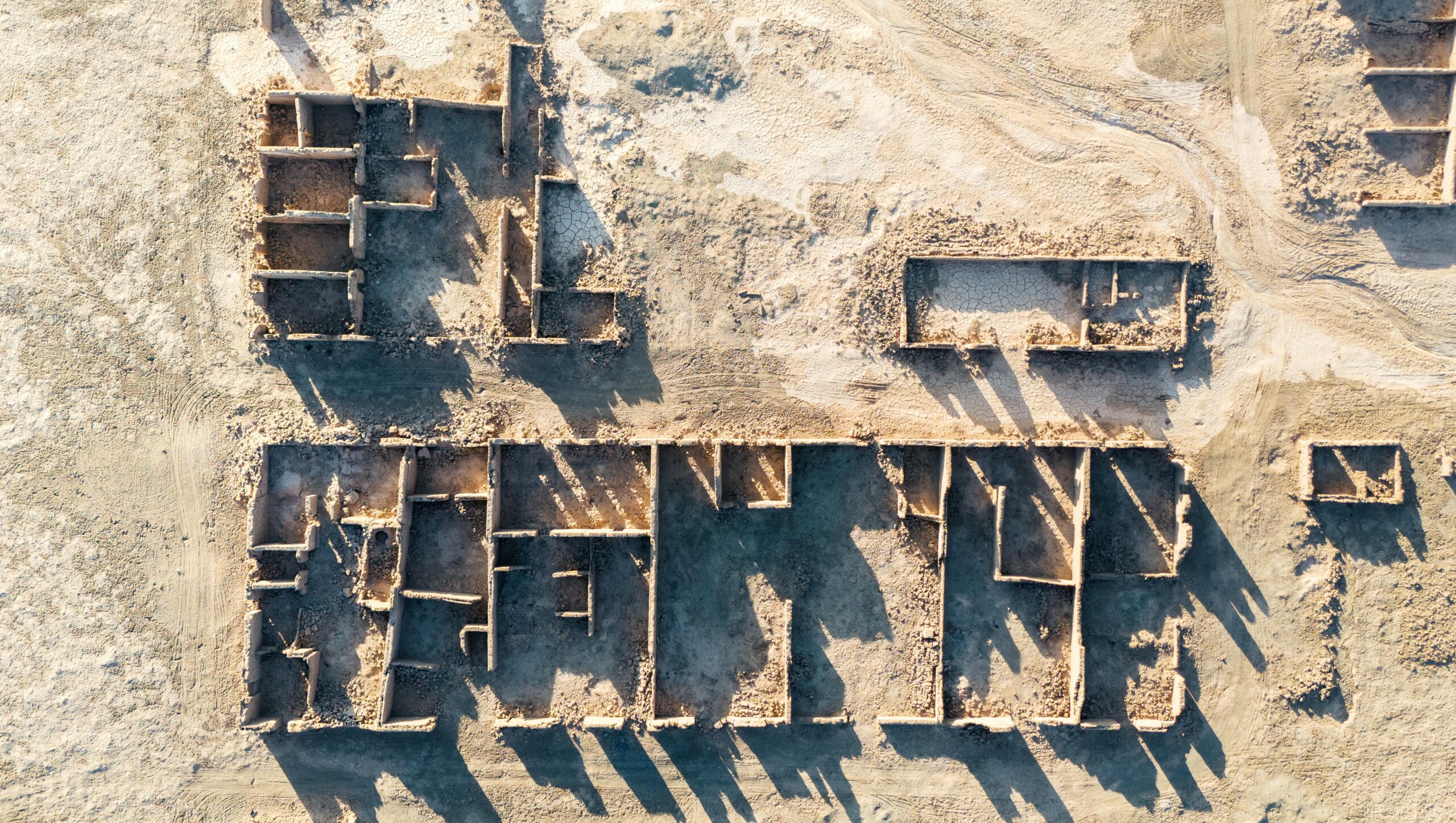
Modern drones equipped with high-resolution cameras can capture imagery with stunning detail, often revealing features invisible to the naked eye from ground level. These flying platforms typically carry cameras capable of producing images with resolutions measured in centimeters or even millimeters per pixel. Such precision allows conservators to detect minute cracks, discoloration, biological growth, or structural deformation before they become critical problems.
Multispectral and thermal imaging sensors add another dimension to heritage monitoring. Multispectral cameras capture data across different wavelengths of light, revealing subsurface features, previous restorations, or moisture intrusion that standard photography cannot detect. Thermal imaging identifies temperature variations that may indicate structural problems, water infiltration, or hidden architectural elements beneath plaster or vegetation.
Photogrammetry—the science of making measurements from photographs—has been transformed by drone technology. By capturing hundreds or thousands of overlapping images from different angles, specialized software can generate precise three-dimensional models of entire heritage sites. These digital twins serve multiple purposes: baseline documentation, virtual tourism, academic research, restoration planning, and education.
Creating Digital Archives for Future Generations
Perhaps one of the most significant benefits of drone monitoring is the creation of comprehensive digital archives. When heritage sites suffer damage or destruction—whether from earthquakes, fires, warfare, or gradual decay—these detailed records become invaluable. They preserve not just visual appearance but precise measurements, spatial relationships, and contextual information that inform reconstruction efforts.
The tragic destruction of sites like Palmyra in Syria demonstrated both the vulnerability of heritage and the importance of digital preservation. Where detailed documentation existed, reconstruction becomes possible. Where it doesn’t, history is lost forever. Drone surveys, conducted systematically over time, create time-series data that documents changes, helps identify deterioration patterns, and informs conservation strategies.
These digital archives also democratize access to heritage. Virtual reality reconstructions based on drone data allow people worldwide to experience sites they might never physically visit. Students in distant countries can explore ancient ruins. Researchers can examine architectural details without traveling. This accessibility extends heritage’s educational and cultural value far beyond physical boundaries.
🌍 Global Applications and Success Stories
Around the world, heritage organizations have embraced drone technology with impressive results. In Peru, drones map extensive Inca trail networks and monitor conditions at Machu Picchu, where millions of annual visitors create conservation challenges. The aerial perspective reveals erosion patterns, vegetation encroachment, and structural stress points that ground surveys might miss.
Italian authorities employ drones to monitor Pompeii, where volcanic ash that preserved the ancient city also creates unique conservation challenges. Regular aerial surveys detect areas where protective coverings have failed, where rainwater pools risk causing collapse, or where vegetation threatens structural integrity. This proactive approach prevents small problems from becoming catastrophic failures.
In Cambodia, conservators use drones to study the massive Angkor Wat complex, spanning over 400 square kilometers. The aerial data revealed previously unknown structures hidden beneath jungle canopy, demonstrated the extent of ancient water management systems, and identified areas requiring urgent conservation intervention. What would have taken months of ground surveying was accomplished in days.
The UNESCO World Heritage Centre has incorporated drone monitoring into management plans for numerous sites globally. From the Great Wall of China to the pyramids of Egypt, from European cathedrals to pre-Columbian settlements in the Americas, drones provide consistent, comparable data that supports informed decision-making.
Cost-Effectiveness and Efficiency Gains
Budget constraints perpetually challenge heritage conservation. Drones offer significant cost advantages over traditional monitoring methods. A single drone operator can survey large areas quickly, eliminating the need for expensive equipment rental, extensive personnel, or prolonged site access disruptions. The same survey that might cost tens of thousands of dollars using helicopters or scaffolding can be accomplished for a fraction of that expense.
Time efficiency matters equally. Rapid deployment means sites can be surveyed following storms, earthquakes, or other incidents while evidence remains fresh. Quick turnaround on data processing means decision-makers receive actionable information faster. This responsiveness can mean the difference between catching problems early and facing costly emergency interventions later.
The return on investment extends beyond immediate cost savings. Early detection of problems typically means less expensive interventions. Comprehensive documentation reduces planning time for restoration projects. Better data supports more successful grant applications. Improved monitoring demonstrates responsible stewardship, building public and donor confidence.
⚠️ Navigating Challenges and Limitations
Despite significant advantages, drone monitoring isn’t without challenges. Regulatory frameworks vary dramatically between countries, with some nations imposing strict limitations on drone flights near historical sites. Operators must navigate complex permission processes, no-fly zones, altitude restrictions, and privacy considerations. Understanding and complying with these regulations requires expertise and patience.
Technical limitations also exist. Weather conditions affect flight safety and data quality—strong winds, rain, or extreme temperatures can prevent operations. Battery life limits flight duration, potentially requiring multiple flights for large sites. Dense vegetation or interior spaces remain difficult to survey effectively from aerial platforms.
Data management presents another challenge. High-resolution surveys generate enormous data volumes requiring substantial storage capacity and processing power. Converting raw imagery into useful information demands specialized software and trained personnel. Organizations must develop systems for data archiving, retrieval, and version control to maximize the value of drone monitoring programs.
Privacy concerns arise when heritage sites are located within or near inhabited areas. Drone cameras can inadvertently capture images of private properties or individuals, raising legal and ethical questions. Operators must balance comprehensive site documentation with respect for privacy rights, often requiring careful flight planning and image processing protocols.
Training the Next Generation of Heritage Technologists
As drone technology becomes integral to heritage conservation, educational institutions are responding with specialized training programs. Universities now offer courses combining archaeology, conservation science, and drone operation. These programs produce professionals who understand both cultural heritage values and technical capabilities—a crucial combination for effective implementation.
Training encompasses more than just flight skills. Heritage drone operators need photogrammetry expertise, data processing capabilities, knowledge of conservation principles, and awareness of ethical considerations. They must understand how to interpret the data they collect, recognizing signs of deterioration, identifying priorities, and communicating findings to diverse stakeholders from technical experts to policymakers to the general public.
Professional organizations have emerged to support this growing field, establishing best practices, facilitating knowledge exchange, and advocating for appropriate policies. These networks help practitioners stay current with rapidly evolving technology while maintaining focus on heritage conservation goals.
🔬 Integration with Other Technologies
Drone monitoring achieves maximum impact when integrated with complementary technologies. Geographic Information Systems (GIS) combine aerial data with historical records, environmental data, and management information, creating comprehensive analytical platforms. Artificial intelligence algorithms can automatically detect changes between surveys, flagging areas requiring human expert review.
LiDAR (Light Detection and Ranging) sensors mounted on drones penetrate vegetation to reveal underlying topography and structures. This technology has revolutionized archaeological prospection, revealing entire hidden cities beneath tropical forests. When combined with traditional photography, LiDAR creates remarkably complete site documentation.
Virtual and augmented reality applications transform drone data into immersive experiences. Visitors at heritage sites can use mobile devices to see reconstructed buildings overlaid on existing ruins. Students can virtually walk through archaeological sites on different continents. These applications enhance public engagement while reducing physical pressure on fragile sites.
Building Information Modeling (BIM) adapted for heritage structures incorporates drone data into comprehensive digital management systems. These platforms integrate geometric information, material properties, historical documentation, and conservation records, supporting long-term stewardship and enabling sophisticated scenario modeling for restoration projects.
Environmental Monitoring and Climate Change Adaptation
Climate change poses existential threats to many heritage sites. Rising sea levels endanger coastal archaeological zones. Increased storm intensity damages structures. Changing precipitation patterns affect moisture-sensitive materials. Temperature fluctuations accelerate weathering. Drone monitoring provides essential data for understanding and responding to these challenges.
Regular aerial surveys document erosion rates, flooding patterns, and vegetation changes that reflect broader environmental shifts. This longitudinal data helps conservators distinguish normal variation from concerning trends, supporting evidence-based adaptation strategies. Thermal imaging reveals how buildings respond to temperature extremes, informing climate-appropriate conservation approaches.
Drones also support ecosystem monitoring around heritage sites. Many archaeological landscapes include significant natural components—ancient agricultural terraces, irrigation systems, or sacred groves. Understanding how changing environmental conditions affect these integrated cultural-natural landscapes requires comprehensive monitoring that drones facilitate efficiently.
🎯 Future Directions and Emerging Possibilities
The future of drone monitoring for heritage sites promises even greater capabilities. Autonomous flight systems will enable regular automated surveys requiring minimal human intervention. Improved sensors will capture even more detailed information across broader spectral ranges. Longer flight times and increased payload capacities will expand what single missions can accomplish.
Artificial intelligence will increasingly automate data analysis, rapidly identifying changes, predicting deterioration patterns, and recommending interventions. Machine learning algorithms trained on extensive datasets will recognize subtle indicators of problems that humans might overlook. These tools won’t replace human expertise but will amplify its effectiveness.
Swarm technology—multiple drones working coordinately—could survey vast sites simultaneously, dramatically reducing time requirements. Indoor drone systems adapted for heritage applications may navigate complex interior spaces, documenting areas currently difficult to access. Improved communication systems will enable real-time data transmission, allowing experts to guide surveys remotely and respond immediately to discoveries.
International collaboration will expand as standardized protocols enable data sharing across borders. Global monitoring networks could track threats to heritage sites worldwide, supporting rapid response to emergencies and facilitating knowledge exchange. Open-access databases would make drone-derived heritage documentation available to researchers, educators, and the public everywhere.
Ethical Considerations and Community Engagement
Technology must serve heritage values rather than overshadow them. Drone monitoring programs should engage local communities, respecting cultural sensitivities and incorporating traditional knowledge. Indigenous peoples and descendant communities often have profound connections to heritage sites that technological approaches alone cannot capture or appreciate.
Transparency in data collection and use builds trust. Communities should understand why monitoring occurs, how information will be used, and who will have access. In some contexts, certain knowledge may be culturally sensitive, requiring careful protocols about what is documented and shared publicly. These ethical considerations must guide technological implementation.
Benefit-sharing models ensure that communities connected to heritage sites gain advantages from monitoring programs. Employment of local operators, capacity building through training, and involvement in decision-making processes create inclusive approaches. Tourism promotion based on drone imagery should economically benefit local populations while respecting site integrity and community wishes.
Soaring Toward Heritage’s Future 🏛️
Drone technology has fundamentally transformed heritage conservation, providing tools that previous generations of conservators could only imagine. The ability to comprehensively document, regularly monitor, and effectively protect cultural heritage sites represents a quantum leap in our capacity to preserve humanity’s shared history for future generations.
As drones become more capable, affordable, and accessible, their role in heritage management will only grow. The challenge lies not in the technology itself but in ensuring its thoughtful application—guided by conservation principles, respectful of communities, and focused on long-term stewardship rather than short-term spectacle. When used wisely, drones help us fulfill our obligation to preserve irreplaceable heritage while making it more accessible and understandable than ever before.
The view from above offers more than stunning imagery; it provides perspective on our place in history’s long arc. By preserving heritage sites through innovative monitoring, we honor past achievements while equipping future generations with the knowledge and resources to continue this essential work. In this way, technology and tradition combine to safeguard humanity’s cultural legacy against the uncertainties of time.